Water network condition surveys, one section at a time
Pipelytica Networks is a service for water utilities and their CCTV contractors for condition surveys of sewer and stormwater networks one section at a time. It combines register import, AI analysis of CCTV video, human-approved condition classes using the utility’s classification profile (the 0–4 scale of the Finnish VVY 2021 guide included), reports and delivery to the utility. Networks is available by contract since 5 October 2026; pricing is by quote.
Networks brings the network register, CCTV videos, inspections, condition classes, reports and delivery to the utility into one service. The AI suggests observations, and people review and approve them.
Networks is available. It is switched on by contract, and the price is agreed after the demo.
What Networks looks like
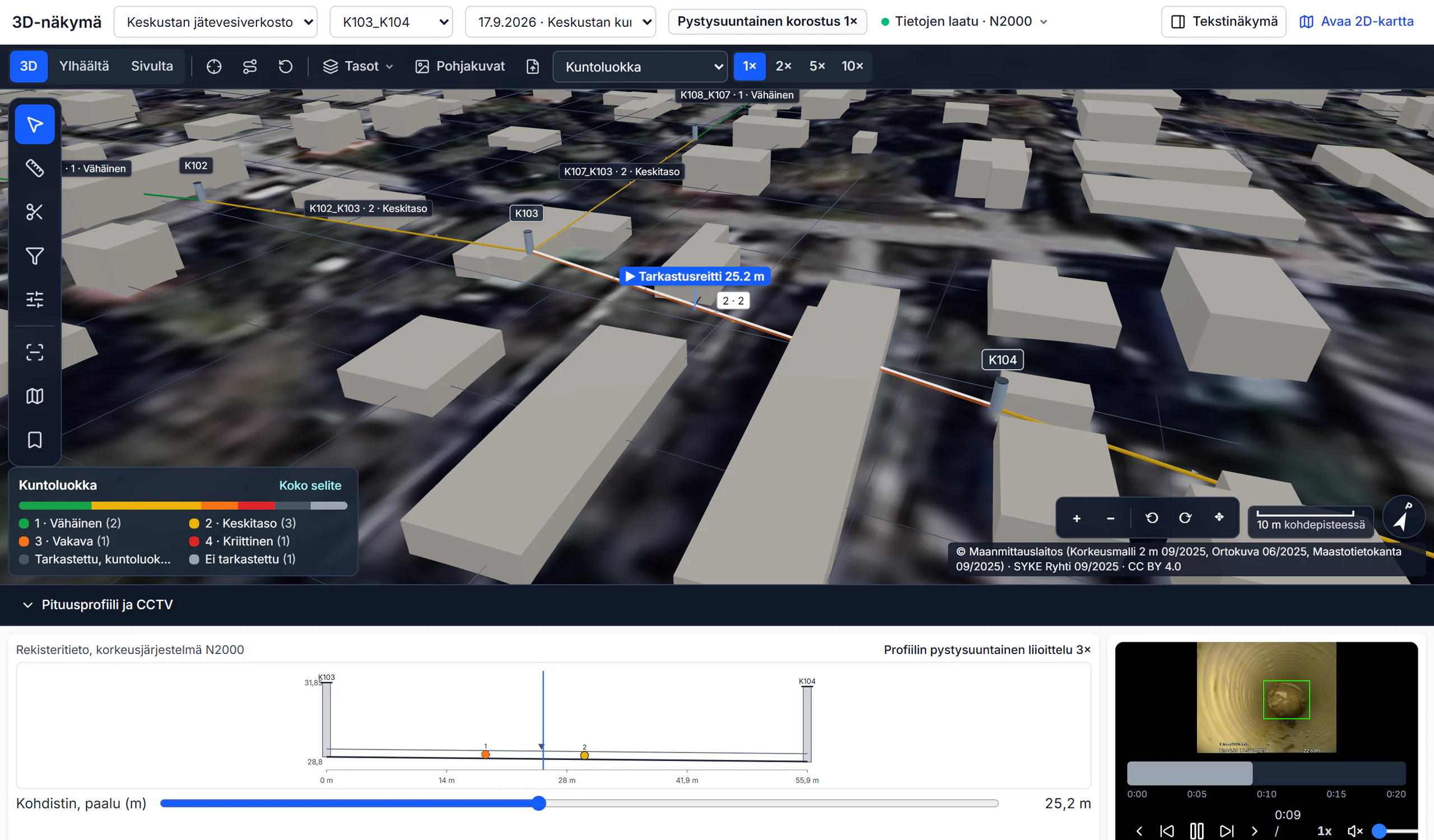
Screens from the service with example data: a fictional utility and network at real coordinates, a fictional housing company. Terrain, orthophoto and buildings are open data of the National Land Survey of Finland and SYKE (CC BY 4.0).
How it works
A condition survey one section at a time, in the order the work proceeds. Every step is a screen from the service.
Network register in
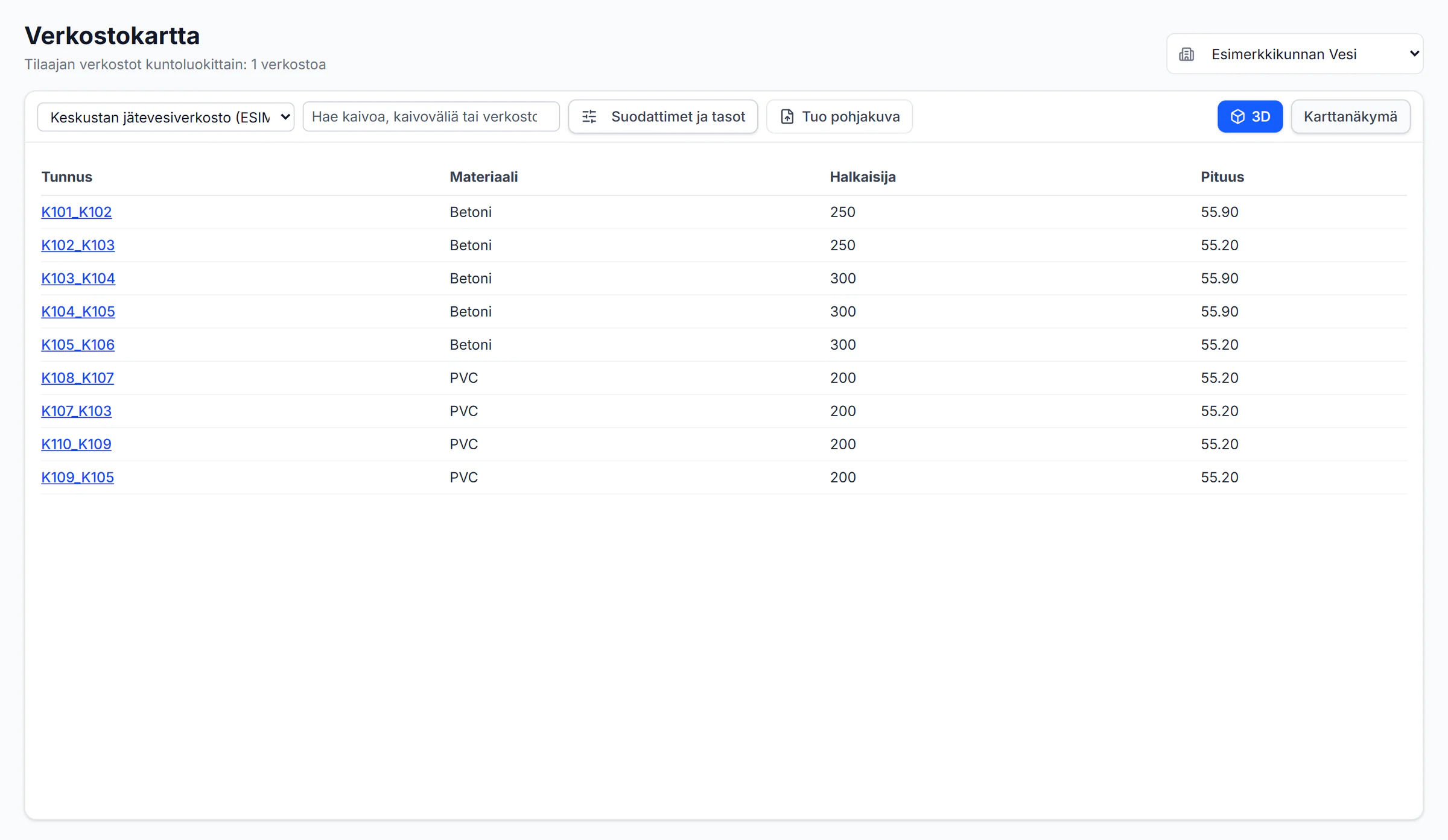
Manholes, sections and connections come from the utility’s register as GeoJSON or CSV. Nothing is written to the register before the import check is accepted.
Order and scope
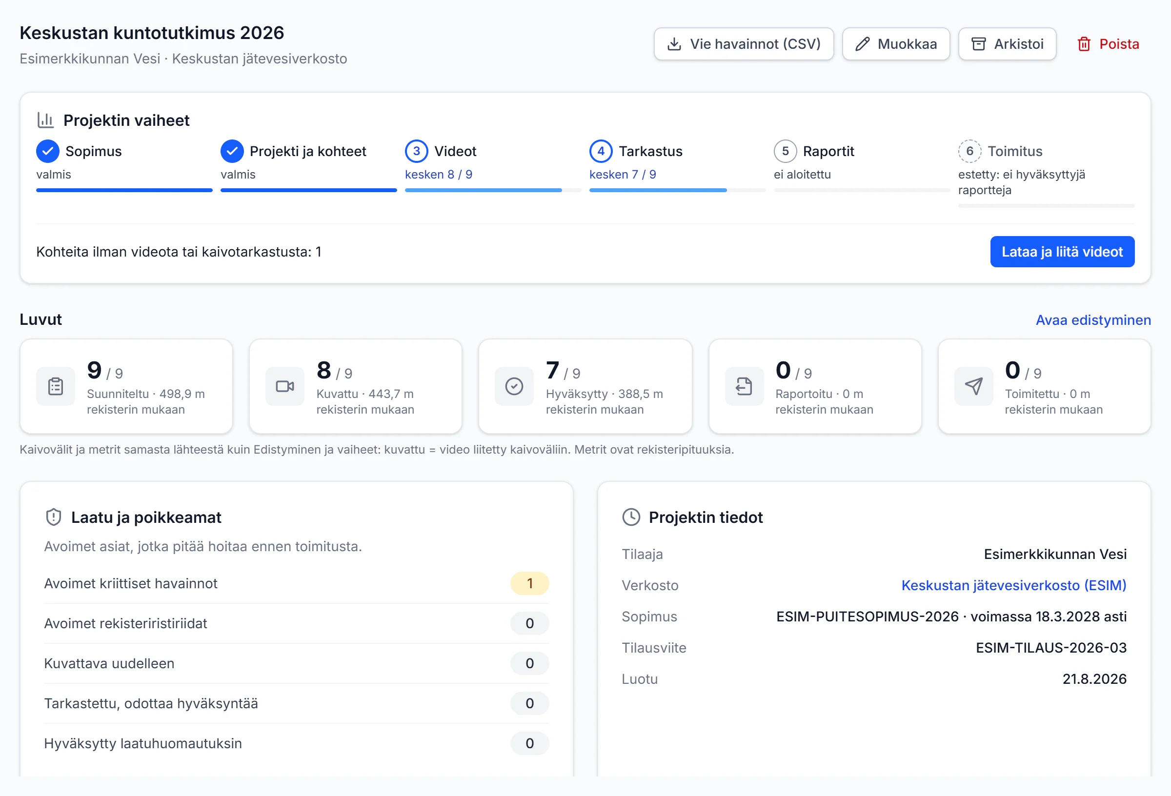
The utility’s assignment in sections: phases, surveyed and approved metres, quality exceptions and the contract on one page.
CCTV review: video and long section on one chainage
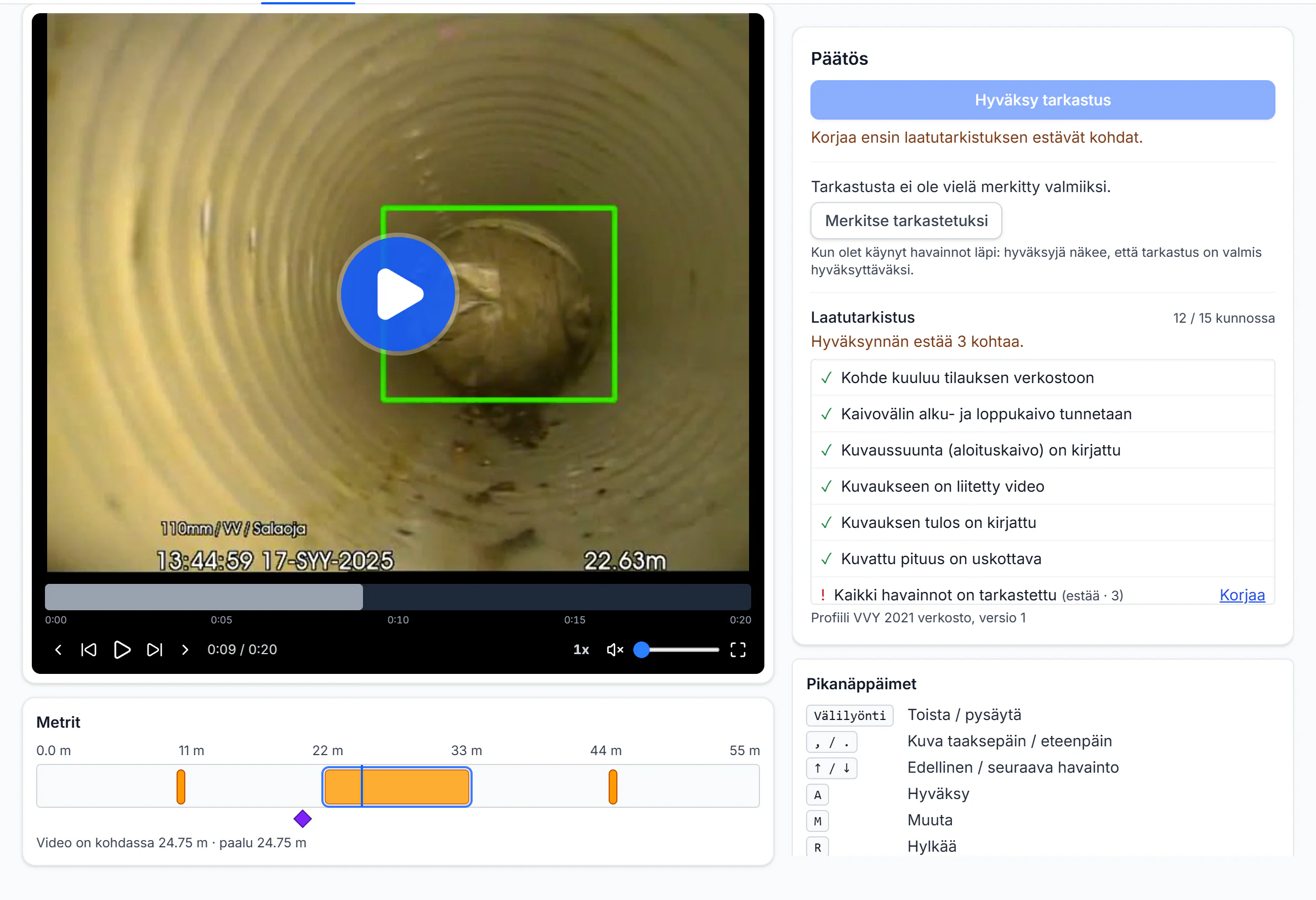
The AI suggests observations onto a metre timeline, a continuous one as a band. The inspector handles every suggestion, and the quality check says what still blocks approval.
Condition classes and critical findings
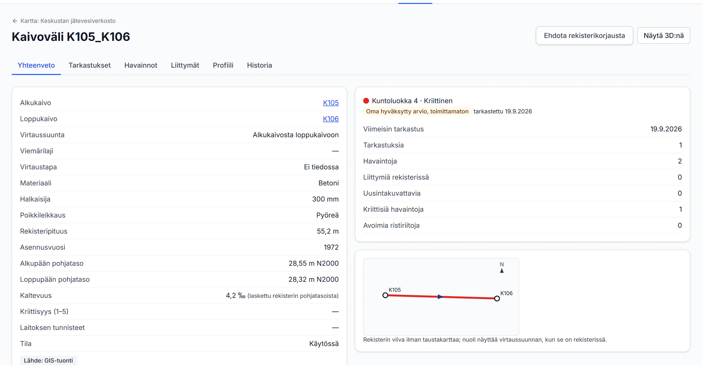
The condition class comes from the utility’s classification profile (the 0–4 scale of the VVY 2021 guide included), observations with EN 13508-2 codes. A critical finding is verified and reported to the utility’s contacts.
Delivery to the utility
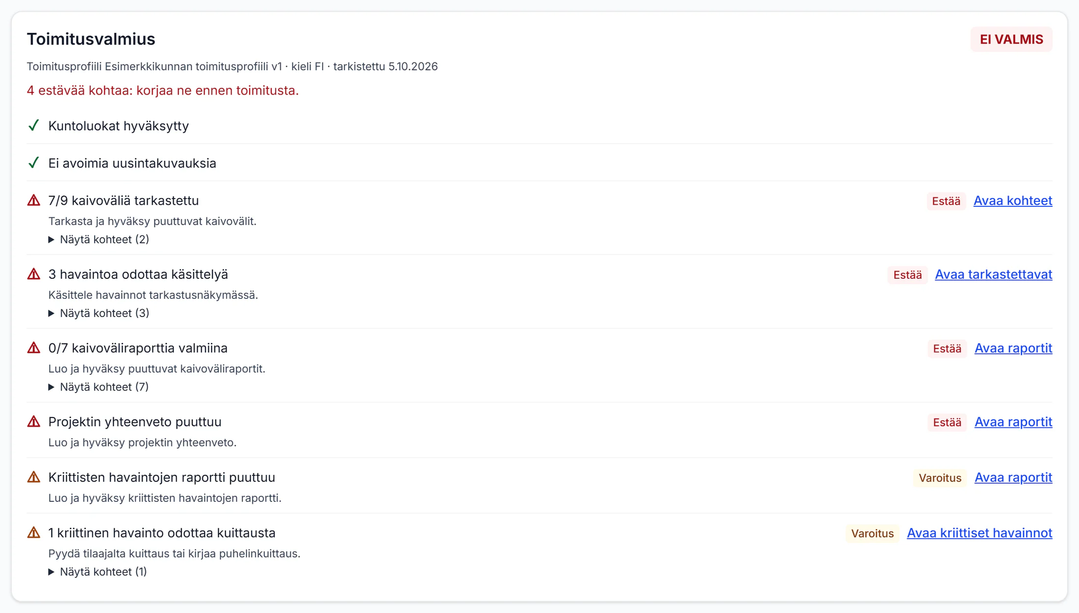
The readiness check says what blocks the delivery: uninspected sections, unprocessed observations, missing reports. The TV3 file is enabled per utility.
Renovation programme
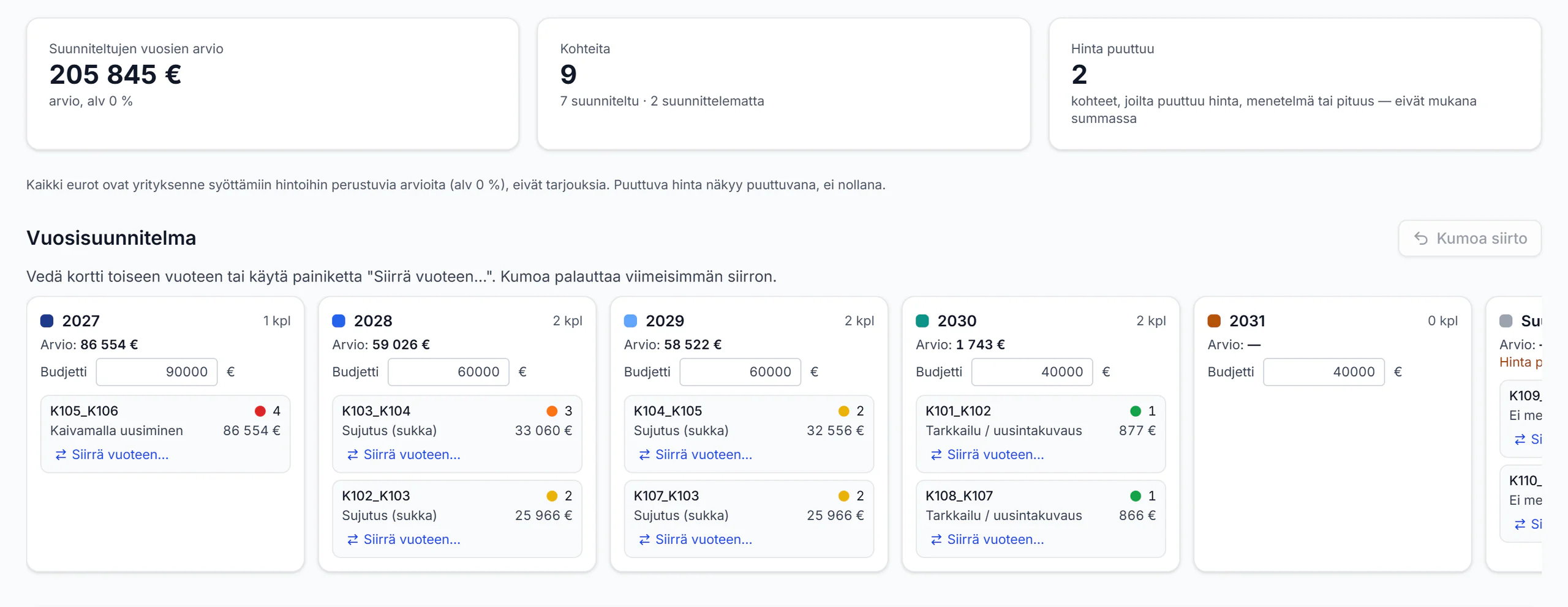
Sections per year in priority order, estimates on the company’s own prices and yearly budgets. A missing price or method shows as missing, never as zero.
3D in the terrain
Sections at their register levels over the National Land Survey terrain model, orthophoto and buildings (open data, CC BY 4.0). The long section and the CCTV video follow the same chainage.
Screens from the service with example data: a fictional utility and network at real coordinates, a fictional housing company. Terrain, orthophoto and buildings are open data of the National Land Survey of Finland and SYKE (CC BY 4.0).
Who it is for
Water utility
The network and its register are yours. You receive critical findings by email with an acknowledgement link, decide on register corrections proposed by the contractor, and receive the delivery through a link where you can accept it or send it back for correction.
CCTV contractor
You survey under the utility's contract. You define the project scope, upload the videos, review observations and condition classes, and deliver reports and technical files to the utility from the same service.
Six steps from contract to delivery
The same steps appear in the progress bar of every project in the service, so you always see what comes next.
Contract
A contractor sees only the networks it holds a valid contract for with the utility.
Project and scope
Sections are added by ID search, by filter or from the utility's own list (CSV or text).
Videos
Upload the CCTV videos. The service suggests the section from the file name, the text in the video or the utility's ID, and you confirm the link.
Review
The AI suggests observations and the inspector reviews them on a metre timeline. An approved inspection can no longer be changed, and a classification profile can require the approver to be someone other than the maker.
Reports
Section reports, manhole cards and the project summary are made from approved data. Reports are numbered, and a correction is a new revision.
Delivery
A readiness check shows what is missing before delivery. The utility receives the delivery through a link and can accept it or request a correction.
What Networks includes
Everything below is built and in use. Each item says who decides.
Network data and owners
- Contracts
- A contractor sees only the networks it has a valid contract for with the owner.
- Who decides: the network owner
- Register import
- GeoJSON and CSV files. The coordinate system (ETRS-TM35FIN, ETRS-GK zones or WGS 84) is confirmed before the import, and changed fields are shown before they are accepted.
- Who decides: a person
- Import history
- Every import and its changes are kept in a history.
- Who decides: runs on its own
- Register discrepancies
- When the survey and the register disagree, the contractor proposes a correction. The register changes only if the owner accepts it.
- Who decides: the network owner
- Customers
- Network owners as customers: contracts, contacts, projects, critical findings and deliveries.
- Who decides: a person
Work section by section
- Projects
- The owners’ jobs as projects in one list.
- Who decides: a person
- Scope
- Sections are added by id search, a filter or the owner’s own list (CSV or text).
- Who decides: a person
- Linking a video to a section
- The service suggests the section from the file name, the video’s title text or the owner’s id. A person confirms the link.
- Who decides: the AI suggests, a person confirms
- Inspection workbench
- Video, metre line, severity grades, clock positions and the length of continuous observations in one view.
- Who decides: the AI suggests, a person confirms
- Approval
- An approved inspection can no longer be changed. A classification profile can require the approver to be someone other than the maker.
- Who decides: a person
- Classification profiles
- Condition classes follow the owner’s profile. A profile with the VVY 2021 scale 0–4 is ready, and a class only counts once a person has approved it.
- Who decides: a person
- Critical findings
- A person marks an observation critical, and the owner’s verified contact gets an email with an acknowledgement link. The acknowledgement is recorded.
- Who decides: a person
- Manhole inspections
- Structure, photos, measured levels with their height system, and incoming and outgoing pipes.
- Who decides: a person
- Re-surveys
- A list of the sections that have to be surveyed again.
- Who decides: a person
Reports and delivery
- Reports
- Section report, project summary and the lists of critical findings and re-surveys as PDF. A correction is a new version.
- Who decides: a person
- Manhole card
- The manhole card is made from the approved manhole inspection.
- Who decides: a person
- Delivery to the owner
- A readiness check shows what is missing. The owner gets a link to accept or return the delivery. CSV and GeoJSON files come with SHA-256 checksums.
- Who decides: the network owner
- TV3 file
- The TV3 file is switched on per owner once the owner has tested it in its own network information system.
- Who decides: the network owner
- Analytics
- The network’s condition, kilometres inspected per year and the re-survey backlog, from approved data.
- Who decides: runs on its own
- Renovation programme
- Section priorities and a multi-year renovation plan built on the condition data.
- Who decides: a person
Map and 3D
- Map
- Condition classes and uninspected sections on the map.
- Who decides: runs on its own
- 3D and long section
- The 3D view, the long section and the CCTV video share one chainage. Nominal levels are marked, and missing depth is never guessed.
- Who decides: runs on its own
- Drawing underlay
- Bring a PDF, PNG, JPEG or DXF drawing onto the map and the 3D view and place it with control points. An underlay is a visual aid, not survey data.
- Who decides: a person
- 3D tools
- A vertical cut along the selected section, a minimap and saved camera views.
- Who decides: a person
- Correction from 3D
- Propose a register correction for a section, manhole or connection straight from the 3D view. The owner decides.
- Who decides: the network owner
- Real surroundings in 3D
- Ground surface (NLS elevation model 2 m, N2000), orthophoto or base map, buildings by floor count (NLS + SYKE Ryhti) and streets from open data (CC BY 4.0). Context, not survey data: pipe depth always comes from the register.
- Who decides: runs on its own
The AI suggests, people decide
Networks uses the same CCTV analysis as Properties. In reports, AI-suggested observations are marked as AI-assisted, and a rejected or undecided suggestion never reaches a report. Condition classes, critical findings and deliveries are always approved by a person.
What we have measured
- The workflow has been tested in a local test environment on 16 real municipal sewer CCTV videos (4 October 2026).
- The section ID was read from the text at the start of the video in 11 of the 16 videos. Other videos are linked to their section by file name or by hand.
- AI detection accuracy has been measured on property inspection videos. The equivalent measurement on network videos has not been done yet.
Coming
These are not built yet or are still in progress.
- Owner portalComing
- Accounts for the owner to view what has been published to them.
- Field scheduleComing
- Planning survey days and a day list on the phone.
- RemindersComing
- Reminders for orders and re-surveys.
Networks: frequently asked
Has the AI been measured on network videos?
Not yet. Accuracy was measured on property videos (34 videos, Sept 2026). The network workflow was tested on 16 municipal videos on 4 Oct 2026; the section ID was read from the video text in 11 of 16.
Is there a free trial for Networks?
No. Networks is switched on by contract and the price is agreed after a demo, based on network size and delivery content.
Which standard does the coding follow?
EN 13508-2 (SFS-EN 13508-2). Condition classes come from the utility’s classification profile; the VVY 2021 0–4 scale is built in. Pipelytica does not claim conformance with other systems (NASSCO PACP, WRc, DWA-M 149-2).
What is the TV3 delivery?
TV3 is a delivery file for network information systems. It is enabled per utility after the utility has tested it in its own system; it is not on by default.
Where is the data stored?
The database, videos and reports are kept on Hetzner servers in Helsinki. Some sub-processors (Vercel, Resend, and Anthropic when the AI summary is in use) may process data outside the EU. Details are in the privacy policy.
Want to see Networks in use?
We will walk you through the whole path from contract to delivery. Pricing is agreed by quote, based on the network size and the delivery content.